Exploring Nighttime Light in the U.S. Southeast
Model specification and evaluation in the tidymodels framework
2021-09-04
1 Introduction
Nighttime lights are an indicator of human presence and have been used for analyzing economic trends in GDP, population, electricity consumption, \(CO_2\) emissions, and other dimensions of human activity and organization(Proville 2017).
The Earth Observation Group (EOG), now at the Colorado School of Mines, makes available average nighttime light products covering much of the world, derived from data collected by the Defense Meteorological Satellite Program’s primary instrument, the Operational Linescan System (DMSP-OLS), employing Visible and Near-Infrared (VNIR) band sensors(Elvidge 1997). Data from this satellite series was collected 1992-2013. DMSP satellites are in sun-synchronized polar orbit at approximately 458 nautical miles(“FACT SHEET: Defense Meteorological Satellite Program” 2003).

DMSP Satellite image. Source: NOAA
1.1 Questions
Using the EOG’s average radiance products(Hsu et al. 2015) with focus on the southeastern United States (where I live):
With what accuracy can I associate average night radiance values with human presence?
Using the models identified in (1), how well can I use average night radiance to predict the same dimension(s) of human presence 10 years later?
1.2 Method
Use data in the form of GeoTIFF files from the Nighttime Lights time series
The files are cloud-free composites made using all the available archived DMSP-OLS smooth resolution data for calendar years. In cases where two satellites were collecting data - two composites were produced. The products are 30 arc second grids, spanning -180 to 180 degrees longitude and -65 to 75 degrees latitude.
Specifically I will use Radiance Calibrated values rather than Digital Number (DN) values. See Radiance data and Intercalibration.
Limit my focus to the southeastern states of the USA and census data from the years 2000 and 2010. As indicators of “human presence” I use data from the US Census Bureau: (A) demographic information (population and median income) and (B) geographic information (legal state and county borders from the TIGER/Line Shapefiles database), all retrieved using the
tidycensusandtigrisR packages.Associate each pixel (radiance value) in the GeoTIFF image with a county based on its position within county borders and calculate average light level per county. Similarly, calculate county land area based on county borders.
Explore models with linear and non-linear associations among county average light levels and county-level demographic data, including transformations of the demographic data to improve linear relationships.
Partition the data into two sets: (1) train-test set and (2) a holdout set for final model evaluation.
Using the best model(s) identified in the prior step, evaluate model performance on 2010 census data, using the EOG’s intercalibration coefficients to enable valid, multi-year comparisons of radiance levels.
1.3 Causal assumptions
In this endeavor, causal relationships are largely unknown and may be highly confounded. Unknown colliders may have large effects. I use only one or two predictor variables, and given the subject matter, there are more than the usual limitations of observational studies.
dag <- dagitty(
'dag{
  rad [response, pos="1,0"]
  pop [exposure, pos="3,0"]
  env [response, pos="2,0"]
  U_env [unobserved, pos="2,1"]
  U_rad [unobserved, pos="1,1"]
  U_pop [unobserved, pos="3,1"]
  U_pe [unobserved, pos="2.5,-0.5"]
  U_er [unobserved, pos="1.5,-0.5"]
  U_env -> env
  rad <- env <- pop
  U_pop -> pop
  U_rad -> rad
  pop -> U_pe -> env
  env -> U_er -> rad
}')

ggdag(dag) +
  theme(panel.grid.major = element_blank(),
        axis.text.x = element_blank(),
        axis.text.y = element_blank()) +
  labs(title = "Proposed causal graph",
       x = NULL,
       y = NULL)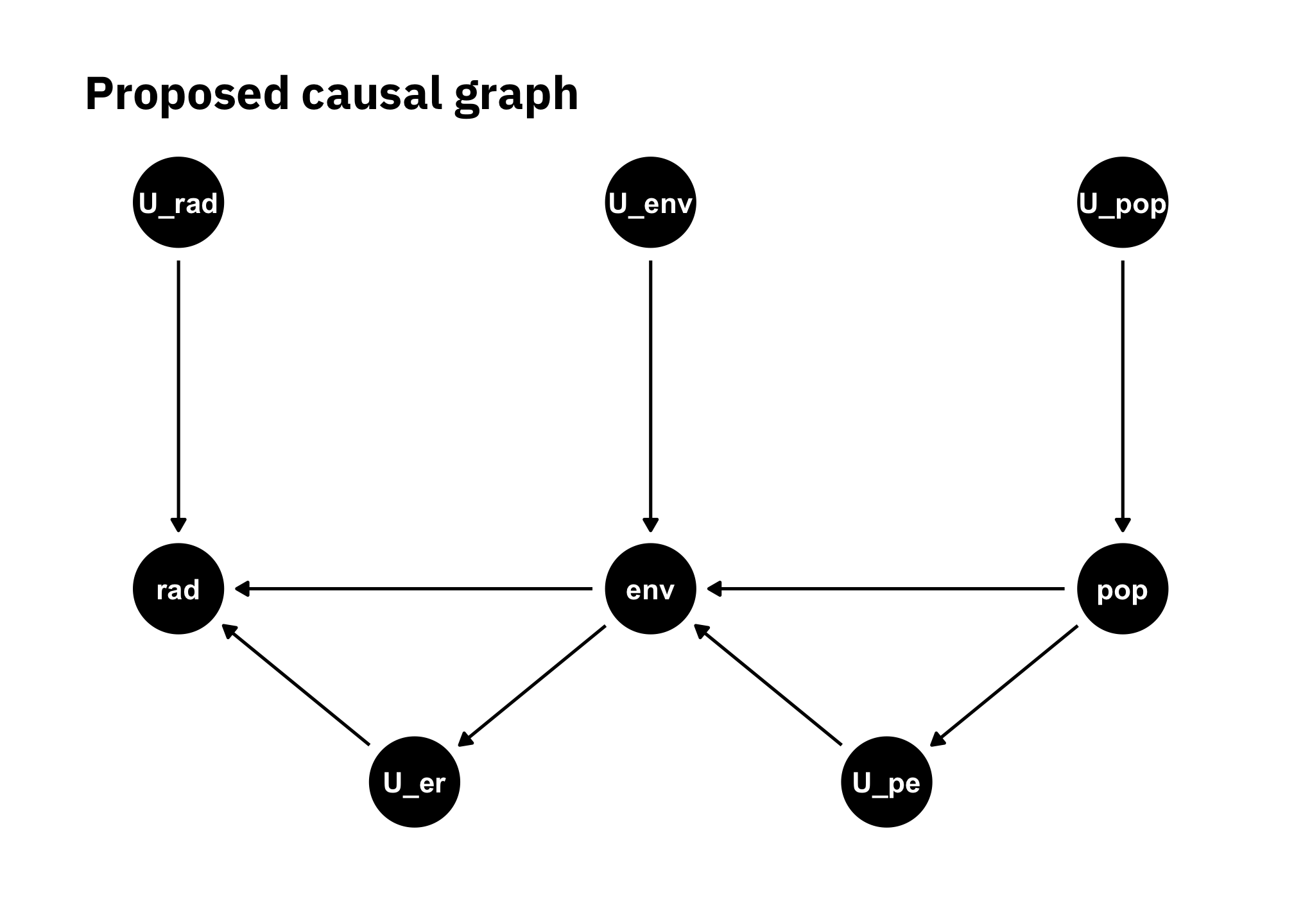
Figure 1.1: Causal graph: there are many confounders and colliders
My conjecture is that greater population density (pop) creates a larger, denser built environment (env) which in turn creates more nightlight (rad). Likely there are unobserved influences (confounders) and sources of error on the measured nightlight (U_rad), including some related to the satellites’ sensors and EOG’s algorithms for determining average nightlight values, radiance values, and intercalibration coefficients. There are many unobserved confounders on population density, including economic conditions, economic growth in various sectors, geography, and zoning laws. Additionally, some of these influences may not have remained constant between 2000 and 2010. There likely are unknown colliders (U_pe and U_er) that mediate the influence of population density on the built environment and the built environment on radiance.
I assume the effect of U_rad is much smaller than U_env, U_c, and U_er. In this case U_pop is not relevant, and similarly, I ignore any influences that mediate changes in population that might change the association between population changes and population density changes.
Given all the above, and the fact that I am building models for a relatively small geographic area and with only one year’s data (and then comparing to only one other year’s data), I do not expect highly accurate predictions.
References
By Daniel Moul (heydanielmoul via gmail)
 This work is licensed under a Creative Commons Attribution 4.0 International License